
You are using an out of date browser. It may not display this or other websites correctly.
You should upgrade or use an alternative browser.
You should upgrade or use an alternative browser.
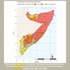
Badhaadhe District gets the most rain in Somalia on average
- Thread starter Abaq
- Start date

Bro I can’t wait to see them green lands wallahi many Somalis would be surprised of how beautiful our land is
Abaq
VIP
No wonder the Gaajo Gedoans try to claim the Jubbas. Badhaadhe, Afmadow, and Bu’aale get the most rain in the country
@Somali Ugaas
@Somali Ugaas
Abaq
VIP
It’s our best kept secret. If only they knew how green and verdant Badhaadhe isBro I can’t wait to see them green lands wallahi many Somalis would be surprised of how beautiful our land is
Abaq
VIP


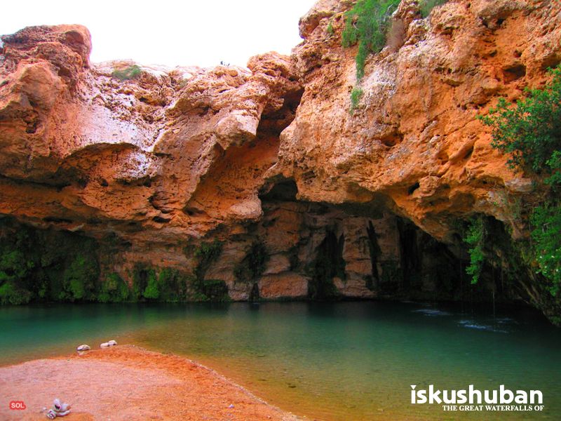
Origin place of tanade and Leelkase. They have waterfalls and spring there and date trees . Never new rain was that bad
Chaseyourdreamzz
VIP
Jubaland has the best pastoral land in somalia mashallah
It's so beautiful though


Chaseyourdreamzz
VIP
The famous dharoor valley is in iskushuban district some of the best grazing land in bari
Do you have any idea why does Kismayo and Jamaame receive less rain water than Buaale even though they are next to Badhaadhe? And what does Badhaadhe mean?
Abaq
VIP
Ah so it gets fed rainwater from other areas. That explains it. Anywhere on a valley is blessed with waterThe famous dharoor valley is in iskushuban district some of the best grazing land in bari
Abaq
VIP
I have no clue why Kismaayo and Jamaame get less rain. Badhaadhe is the same as Baraare in other words barwaaqo. The district is named after the district capital which is the greenest Somali city on the planet. When OG first came across it, they called it Badhaadhe as they were amazed at how green and full of water it was (OG in Ogadenia use the Dh rather than R reer Koonfur use). Badhaadhe district is dotted with lakes which extend to Afmadow district and are known as Haro Waamo. Some are seasonal, some are more permanentDo you have any idea why does Kismayo and Jamaame receive less rain water than Buaale even though they are next to Badhaadhe? And what does Badhaadhe mean?
Is the land hilly around Baraare or flat? If its bit hilly it will contain more rainwater and the area stays more resilient in the face of failed rain water, right?I have no clue why Kismaayo and Jamaame get less rain. Badhaadhe is the same as Baraare in other words barwaaqo. The district is named after the district capital which is the greenest Somali city on the planet. When OG first came across it, they called it Badhaadhe as they were amazed at how green and full of water it was (OG in Ogadenia use the Dh rather than R reer Koonfur use). Badhaadhe district is dotted with lakes which extend to Afmadow district and are known as Haro Waamo. Some are seasonal, some are more permanent
And also is this beautiful land around Burgabo like a Fjord(sea water pushing inland) or river flowing to ocean?
Abaq
VIP
It’s sea water. A tog discharges into the ocean where it begins. There’s a town up that stretch from Buurgaabo called Buushbuushle that has a well with permanent freshwater right next to the shore with salty water. It is most flat with a few hills and valleysIs the land hilly around Baraare or flat?
And also is this beautiful land around Burgabo like a Fjord(sea water pushing inland) or river flowing to ocean?
View attachment 263432
Abaq
VIP
@Rationale use the map on this website instead of Google maps. It is way clearer and more up to date. This spot is Badhaadhe town
 satellites.pro
Somalia map satellite // Africa
🌍 map of Somalia, satellite view. Real picture of Somalia regions, roads, cities, streets and buildings - with labels, ruler, search, locating, places sharing, weather conditions etc.

Are we the ones who are gaajo?No wonder the Gaajo Gedoans try to claim the Jubbas. Badhaadhe, Afmadow, and Bu’aale get the most rain in the country
@Somali Ugaas
xishood waarya, take a good lol at this almost all other daarod majority areas are on top laakin OG are the only ones behind. Get your PM to help YOUR gaajo people.
Abaq
VIP
There is only one catch to the two Jubbas: the tsetse flies (gendi). Only the livestock that are originally from the region can survive, livestock brought from elsewhere quickly get sick or die. Our livestock are used to it and thriveJubaland has the best pastoral land in somalia mashallah