
I did a deep drive, originally thinking this was a hoax, but it turns out it's real, the tech isn't new but was adapted for use to use satellite scans, it's called SAR Doppler Tomography and was used previously to scan volcanoes, the two Italians adapted it for use on archaeological sites.
This doesn't require any permission and opens up a whole new world for archaeologists.
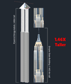
On March 16th, 2025, an interdisciplinary team of researchers announced a groundbreaking discovery beneath Egypt’s Giza Plateau: a vast complex of underground chambers and shafts extending nearly two kilometers under the famous pyramids. The team – consisting of Professor Corrado Malanga, Dr. Filippo Biondi, and Dr. Armando Mei – utilized advanced radar imaging technology to “see” almost 2 miles (approximately 3 km) below ground without excavation. In the press release, Malanga, Biondi, and Mei unveiled high-resolution 3D radar scans purportedly showing multiple levels of unknown structures hidden deep below the Great Pyramids. These findings could revolutionize our understanding of ancient Egyptian engineering and lend credence to long-standing legends of hidden chambers at Giza.
I have been in contact with one of the team members and have viewed the entire symposium and can say the presentation was professional and a landmark. I am working on a specific AI model to assist in producing higher-resolution images and to have higher discrimination between different types of Doppler effects (see below for more details on what this means).
How is it possible to “see” this deep underground? To probe beneath the pyramids, the team employed cutting-edge Synthetic Aperture Radar (SAR) imaging combined with a novel Doppler tomography technique. SAR is a form of radar remote sensing that uses the motion of a radar antenna (often on a satellite or aircraft) to simulate a large antenna aperture, yielding very high-resolution images. In this case, radar satellites – including Italy’s COSMO-SkyMed constellation and data from Capella Space – were used to scan the Giza pyramids from orbit. These satellites operate in the X-band frequency (~9.6 GHz, with ~3 cm wavelength), which provides fine image detail. Typically, radar signals at such high frequency penetrate only a few meters into dry ground at best, meaning conventional SAR would only map surface features. The key innovation by Biondi and Malanga was to overcome this limitation by analyzing the micro-vibrations of the structures rather than relying on direct wave penetration.
Advanced Radar Technology: Scanning Deep Beneath Giza
The radar technique – described in a 2022 Remote Sensing journal paper – exploits the natural, tiny vibrations of the pyramid and subsurface rock induced by ambient seismic waves (essentially the “background hum” of the Earth). As seismic energy passes through and around the pyramids, it causes microscopic movements (on the order of millimeters or less) in both solid rock and any voids (empty spaces) underground. The SAR satellites, imaging the site repeatedly, can detect these micro-movements as subtle phase shifts or Doppler frequency shifts in the radar echoes.

In effect, the pyramids and subsoil were rendered transparent when observed in the micro-motion domain. The SAR system operated at X-band, a high-frequency radar known for high imaging resolution. While such high-frequency signals do not directly penetrate kilometers of rock, the team’s method sidestepped this by using the radar to sense surface displacements caused by deeper phenomena. Each radar image was processed using a multi-chromatic analysis (MCA) that split the radar data into many narrow Doppler sub-bands.
By tracking minute Doppler shifts (so-called micro-Doppler effects) induced by vibrating targets, the algorithm inferred the presence of cavities or structures affecting the vibration modes. This approach is akin to medical ultrasound or sonar in concept but uses radar waves and naturally occurring seismic “noise” as the source of illumination. By combining multiple viewing angles and repeated passes, the team achieved a full 3D underground imaging (tomography) with meter-scale resolution. As the researchers describe, “Khnum-Khufu (the Great Pyramid) becomes transparent when observed in the micro-movement domain”, allowing high-resolution reconstruction of internal objects.


This doesn't require any permission and opens up a whole new world for archaeologists.
On March 16th, 2025, an interdisciplinary team of researchers announced a groundbreaking discovery beneath Egypt’s Giza Plateau: a vast complex of underground chambers and shafts extending nearly two kilometers under the famous pyramids. The team – consisting of Professor Corrado Malanga, Dr. Filippo Biondi, and Dr. Armando Mei – utilized advanced radar imaging technology to “see” almost 2 miles (approximately 3 km) below ground without excavation. In the press release, Malanga, Biondi, and Mei unveiled high-resolution 3D radar scans purportedly showing multiple levels of unknown structures hidden deep below the Great Pyramids. These findings could revolutionize our understanding of ancient Egyptian engineering and lend credence to long-standing legends of hidden chambers at Giza.
I have been in contact with one of the team members and have viewed the entire symposium and can say the presentation was professional and a landmark. I am working on a specific AI model to assist in producing higher-resolution images and to have higher discrimination between different types of Doppler effects (see below for more details on what this means).
How is it possible to “see” this deep underground? To probe beneath the pyramids, the team employed cutting-edge Synthetic Aperture Radar (SAR) imaging combined with a novel Doppler tomography technique. SAR is a form of radar remote sensing that uses the motion of a radar antenna (often on a satellite or aircraft) to simulate a large antenna aperture, yielding very high-resolution images. In this case, radar satellites – including Italy’s COSMO-SkyMed constellation and data from Capella Space – were used to scan the Giza pyramids from orbit. These satellites operate in the X-band frequency (~9.6 GHz, with ~3 cm wavelength), which provides fine image detail. Typically, radar signals at such high frequency penetrate only a few meters into dry ground at best, meaning conventional SAR would only map surface features. The key innovation by Biondi and Malanga was to overcome this limitation by analyzing the micro-vibrations of the structures rather than relying on direct wave penetration.
Advanced Radar Technology: Scanning Deep Beneath Giza
The radar technique – described in a 2022 Remote Sensing journal paper – exploits the natural, tiny vibrations of the pyramid and subsurface rock induced by ambient seismic waves (essentially the “background hum” of the Earth). As seismic energy passes through and around the pyramids, it causes microscopic movements (on the order of millimeters or less) in both solid rock and any voids (empty spaces) underground. The SAR satellites, imaging the site repeatedly, can detect these micro-movements as subtle phase shifts or Doppler frequency shifts in the radar echoes.
In effect, the pyramids and subsoil were rendered transparent when observed in the micro-motion domain. The SAR system operated at X-band, a high-frequency radar known for high imaging resolution. While such high-frequency signals do not directly penetrate kilometers of rock, the team’s method sidestepped this by using the radar to sense surface displacements caused by deeper phenomena. Each radar image was processed using a multi-chromatic analysis (MCA) that split the radar data into many narrow Doppler sub-bands.
By tracking minute Doppler shifts (so-called micro-Doppler effects) induced by vibrating targets, the algorithm inferred the presence of cavities or structures affecting the vibration modes. This approach is akin to medical ultrasound or sonar in concept but uses radar waves and naturally occurring seismic “noise” as the source of illumination. By combining multiple viewing angles and repeated passes, the team achieved a full 3D underground imaging (tomography) with meter-scale resolution. As the researchers describe, “Khnum-Khufu (the Great Pyramid) becomes transparent when observed in the micro-movement domain”, allowing high-resolution reconstruction of internal objects.
Attachments
Last edited:


