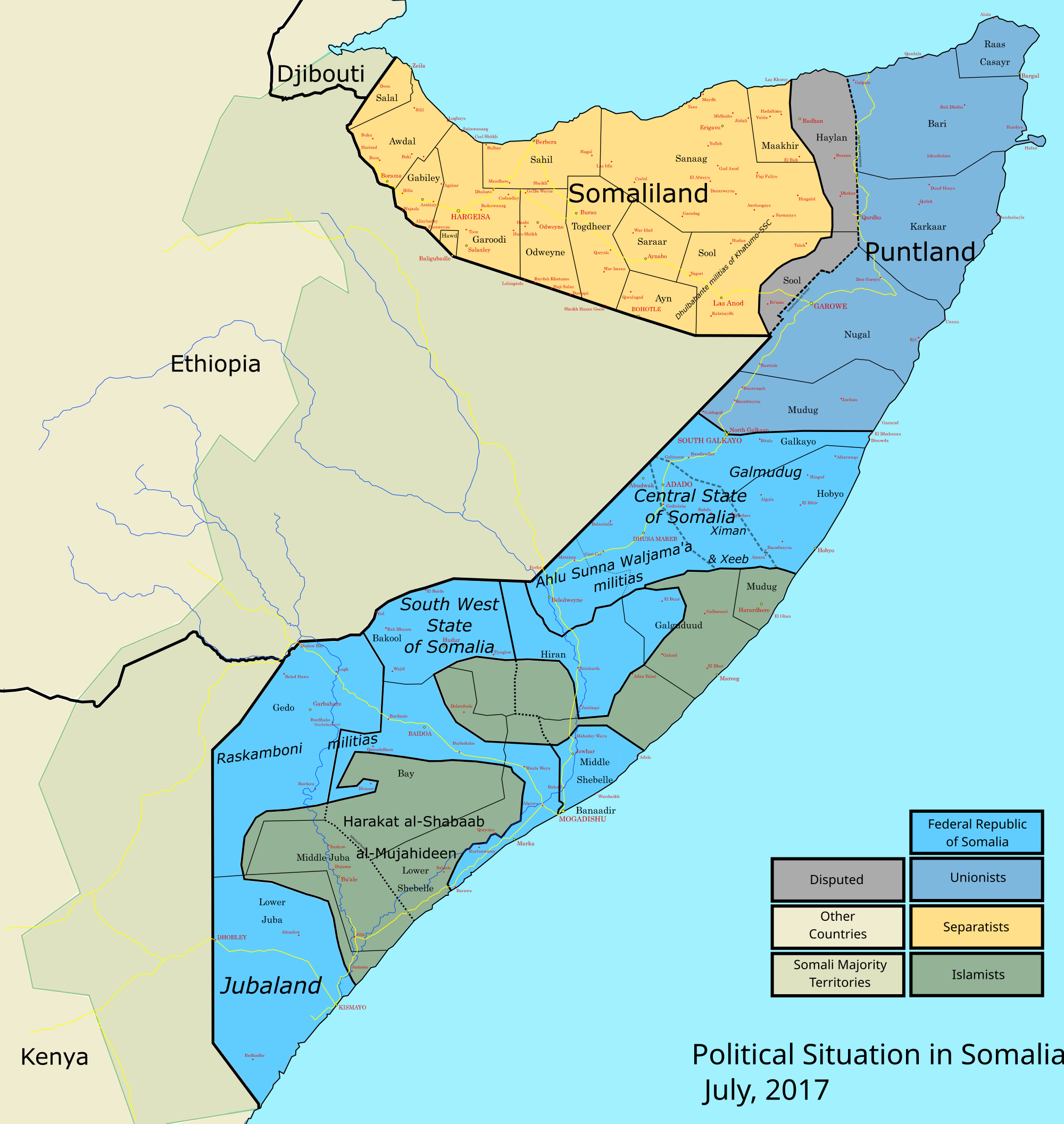
How accurate is this political map from April 2017?

Status
Not open for further replies.

Hoosjeed

Guusha ya leh?
Any major inaccuracies that stand out to you in this map? Mostly interested in Puntland and Koonfur especially since my knowledge on these areas is more limited. Somaliland looks ok for the most part in my opinion except some villages are in the wrong gobols. Ex: Dilla is in Awdal, not Gabiley region.
2000px-Somalia_map_states_regions_districts.svg.png
 

Bohol

VIP
It shows Gabiley district as landlocked since it is true. Sabawanaag and the northern coasts above it is settled by Gadabursi and it
comes under Lughaya district.
 
That map is fake the large area between xudun and taleh dhulos sub clans control :manny:
This is collaborated by them begging UK to train new militia to fight these groups back in 2014 hurofadhi in Buhodle district has never been part of somaliland:manny:
Lol this be map is using sl region drawing which nobody recognize it Sool and Buhodle are bigger than in this image :bell:
 
Last edited:
KDF conceded the rural areas in JL to AS and are mostly resigned to their FOBS that dot across the territory and urban centres. It's a precarious situation over there and at max they only have nominal control.

Farmaajo needs to capture the barawe-jilib road if he wants to deliver the death-knell to AS in JL
 

Hoosjeed

Guusha ya leh?
It shows Gabiley district as landlocked since it is true. Sabawanaag and the northern coasts above it is settled by Gadabursi and it
comes under Lughaya district.

Those are traditional HA degaans you listed. Most of it is deserted today, but the Bulaxaar coast at it's height was dominated by HA. After the place was destroyed by sandstorms in the late 1800's HA left and settled at Berbera and the rest went further south to Gabiley, Hargeisa and the Hawd.

Today the remaining population there is split between Habar Awal and Samaroon reer miyi.
 

Bohol

VIP
Those are traditional HA degaans you listed. Most of it is deserted today, but the Bulaxaar coast at it's height was dominated by HA. After the place was destroyed by sandstorms in the late 1800's HA left and settled at Berbera and the rest went further south to Gabiley, Hargeisa and the Hawd.

Today the remaining population there is split between Habar Awal and Samaroon reer miyi.


I agree with Bulaxaar that is a HA village. However Sabawanaag is Gadabursi. @Rooble

"the Bay of Samawanak, along the Gadiboursi coast"

Y51lVeO.png
 

Hoosjeed

Guusha ya leh?
That map is fake the large area between xudun and taleh dhulos sub clans control :manny:
This is collaborated by them begging UK to train new militia to fight these groups back in 2014 hurofadhi in Buhodle district has never been part of somaliland:manny:
Lol this be map is using sl region drawing which nobody recognize it Sool and Buhodle are bigger than in this image :bell:

What's the political dynamics in this area? Can you explain a bit more?

I didn't make this map btw.
 

Hoosjeed

Guusha ya leh?
I agree with Bulaxaar that is a HA village. However Sabawanaag is Gadabursi. @Rooble

"the Bay of Samawanak, along the Gadiboursi coast"

Y51lVeO.png

Yeah. These borders changed all the time. Jibril Abokor (HA) used to raid this coastal area all the time so it most likely changed hands frequently.


We calmed down quite a bit after we settled in Gabiley and Hargeisa though :pachah1:
 
What's the political dynamics in this area? Can you explain a bit more?

I didn't make this map btw.
Yeah I know you didn't you should take it with a grain of salt
I'll show an example
2iqbuk7.png

Less than a year later
Somalia_2011.png

Keep in mind no fighting happened in South Sool to make the shift IN that time:russ:
 

Reer-Bari

COMMANDER OF THE PUNTLAND DEFENCE TEAM
Any major inaccuracies that stand out to you in this map? Mostly interested in Puntland and Koonfur especially since my knowledge on these areas is more limited. Somaliland looks ok for the most part in my opinion except some villages are in the wrong gobols. Ex: Dilla is in Awdal, not Gabiley region.

2000px-Somalia_map_states_regions_districts.svg.png
Lol most of sanaag is controlled by puntland. Somaliland only has a presence up to erigavo. And some tuulos have both Puntland and Somaliland police stations and troops living along side each other. But only Somali and Puntland flags are allowed to be erected. Both forces are families from the same tribe so they would never attack each other. Lol they chew with each other every night wearing different uniforms. Its a joke
 

Cognitivedissonance

A sane man to an insane society must appear insane
Stay WOKE
VIP
Any major inaccuracies that stand out to you in this map? Mostly interested in Puntland and Koonfur especially since my knowledge on these areas is more limited. Somaliland looks ok for the most part in my opinion except some villages are in the wrong gobols. Ex: Dilla is in Awdal, not Gabiley region.

2000px-Somalia_map_states_regions_districts.svg.png
In sha Allah the somalidiids of somaliland icitiraaf jihadis will be wiped out yaa Allah help us destroy these icitiraaf terrorists amiin yaa rabb.
 

Tjioux

the pussy is never yours, its just your turn.
Any major inaccuracies that stand out to you in this map? Mostly interested in Puntland and Koonfur especially since my knowledge on these areas is more limited. Somaliland looks ok for the most part in my opinion except some villages are in the wrong gobols. Ex: Dilla is in Awdal, not Gabiley region.

2000px-Somalia_map_states_regions_districts.svg.png
Since when did Somaliland control Laas qorey, Yube, hadaaftimo, El buh , Hingalol :dead:
 
Status
Not open for further replies.
Top